 |
| Polarized 2012 vote for U.S. House of Representatives (Click on map to enlarge) |
The map above shows how politically polarized was the 2012 vote for members of the U.S. House of Representatives. It comes from a recent Washington Post article, "Shutdown’s roots lie in deeply embedded divisions in America’s politics."
Each congressional district in each state is represented by a colored square. The deeper the color in each district, the more one-sided the vote was for either the Republican winner in 2012 (red) or the Democratic winner (blue). (Two districts that are now vacant are shown in gray.) The pastel colors represent districts where the vote was "close," while deeper blues and reds signify "safe" districts where the 2012 winner is either very likely to be re-elected in 2014 (the medium shades) or a virtual shoo-in (the deepest shades).
Notice how blue the states from New Jersey and New York up into New England are, and likewise the West Coast states. Also notice how red the states of the Deep South are. But even the reddest state has its pockets of blue, while some (but not all) of the blue states have their own pockets of red.
 |
| Washington Post columnist Colbert King |
The insurgents of the New Confederacy equal, of course, the tea party. It is in the reddest districts that we are most apt to find a tea party-affiliated member of the House. King writes: "[The] conservative extremists, roughly 60 of them by CNN’s count, represent congressional districts in Alabama, Arizona, California, Colorado, Florida, Georgia, Illinois, Indiana, Iowa, Kansas, Louisiana, Maryland, Michigan, Minnesota, Missouri, Mississippi, Montana, Nebraska, New Mexico, North Carolina, South Carolina, Tennessee, Texas, Utah and West Virginia."
Many of these states are ones that made up the Old Confederacy during the Civil War (shown here in yellow):
 |
| (Click on map to enlarge) |
Yet it seems that tea partiers in Congress also come from Arizona, California, Colorado, Illinois, Indiana, Iowa, Kansas, Maryland, Michigan, Minnesota, Missouri, Montana, Nebraska, New Mexico, Utah, and West Virginia. Maryland, Missouri, and West Virginia were "border states" where slavery was legal, but which did not secede from the Union. Some of the remainder of the tea-party states were territories during the 1861-1865 Civil War, and were settled in large part by whites who originated in the Confederate States. Yet others, though they were "free states" where slavery was illegal, arguably were settled by people of the same cultural backgrounds as the southerners, which might explain why certain districts in Iowa, Illinois, and Indiana, went to tea partiers in 2012, and why Ohio is such a crazy quilt of red and blue that it so often acts as the decisive "swing state" in presidential elections.

Here's a map of the eleven "American nations," including "First Nation":
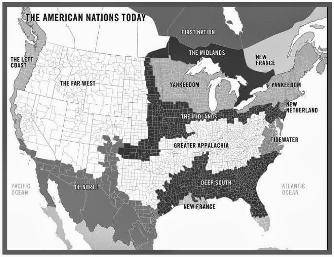 |
| The eleven American "nations" (Click on map to enlarge) |
Compare this map with the first one above showing the blue and red congressional districts. Notice in the first map how blue most of "Yankeedom" is, both in its original East Coast wing and in its later-settled Upper Midwest wing. Ever wonder why Minnesota is so traditionally blue? Well, it was settled in large part by people moving westward from New England and New York, in the East Coast part of "Yankeedom." And those people of eastern "Yankeedom" had their Old World roots in Puritan society in England during the 1600s. The Puritans brought certain cultural assumptions with them to the New World — ones that have led their descendants to be abolitionists who opposed slavery in the nineteenth century, and to be progressives who have voted solidly Democratic in the twentieth. Moreover, it was their "Yankeedom" posterity who were the main non-Hispanic whites to settle the coast of California, Oregon, and Washington — and on up into Canada — to make up the solid-blue nation Woodard calls "Left Coast."
 |
| Journalist-author Colin Woodard |
Look at the "Midlands," a "nation" that sprang from the westward movement of settlers coming from much of Pennsylvania. Those Pennsylvanians in "Midlands" were originally Quakers who, though they had different cultural norms than the Puritans, were notably tolerant of all peoples and engendered a polity that today favors the liberal desideratum of multiculturalism. That polity in the present day tends to the blue end of the spectrum. Notice that "Midlands" crosses through Illinois, just below Chicago, explaining why the blue parts of Illinois in the first map are not just centered in the Windy City, which is actually in "Yankeedom" anyway. Bluish "Midlands" widens out in Missouri, Iowa, and points south and west, possibly explaining many of the blue squares in those areas on the first map.
The "Far West" provides few squares of any color to the first map because it remains so thinly populated. Look at Colorado in the first map; it's both blue and red. Since much of the "Far West" was settled, late in the game of spreading westward, by people who came from the Confederacy or its cultural soulmates on its periphery, it's no wonder there are so (relatively) many red squares in Colorado and in the other states of the "Far West" nation.
Admittedly, there have to be yet other factors helping to explain why some regions and states are solid red, some are solid blue, and some are mixed. But Woodard's concept of eleven separate "nations" that we are no longer very aware of but explain a lot of our entrenched cultural and political attitudes goes a long way toward answering that question.
No comments:
Post a Comment